
While the M25 and M26 projects were never supposed to be completed
in the manner in which they ultimately ended up, the current traffic
patterns, congestion, poorly-suited slip roads (ramps) and lack of
grade-separated motorway movements for certain segments of the interchange
are traffic hazzards and ongoing sources of significant congestion.
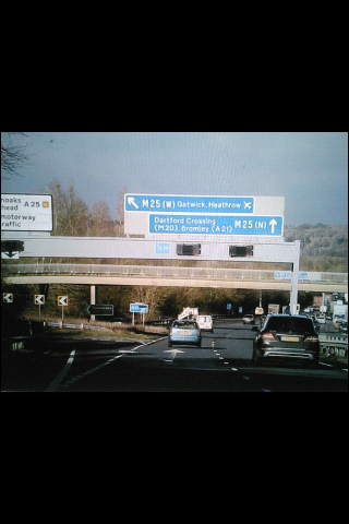
Left: The M20/M26 westward split; traffic to the left is heading due west to the (oddly unsigned) M26 which then merges in a problematic partial interchange with the M25 just west of Dunton Green/Sevenoaks, while traffic to
the right will head northwest to meet with the M25 south of the Dartford (Thames) crossing - once either the M26 or the M20 is taken, there is no way to access the M25 north via the M26, and there is no way to access the M25 south via the M20, requiring d
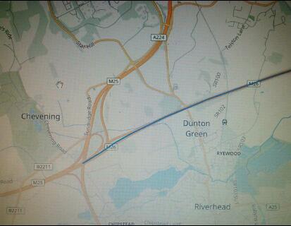
rivers to use local roads to access points between the M26/M25 and the M20/M25 junctions; Right: A map of the partial interchange at the M25/M26 Junction in Dunton Green/Sevenoaks which doesn't allow for moves from the M26 west to the M25
north, and similarly fails to provide for moves from the M25 south to the M26 west. These moves can be made using the M20 if coming south from the Dartford Crossing, or the M25 heading west at the M26 junction, but for traffic entering closer to Dunton G
reen, there is no way to accomplish said moves while remaining on motorways, leading to a lot of uncessary traffic in Dunton Green/Sevenoaks.
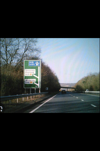
Left: A shot of an exit sign on the M25, south of the M20 split. At this point, traffic requiring the M26 has no direct, motorway-grade (M) option, and must exit the M25 and use local roads in Dunton Green/Sevenoaks to acce
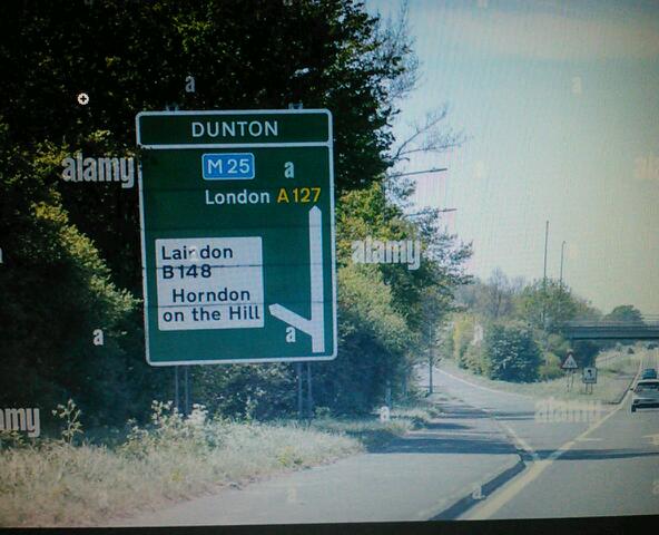
ss the M26 (which itself has too few junctions until well east of Sevenoaks); Right: Not to be confused with the Dunton Green interchange in Kent, this sign is further north on the M25, near Upminster, at the A127 junction. Had t
he M25 been built as planned, Dunton would have been between the outermost (fourth) M26 orbital east of Dunton (depending on where the M26 would have ended as it was not going to be a complete orbital in the east), and a more inner M25 (third) circular mo
torway surrounding London, and the A127 could have been used to travel between the two had the M26 been built down that far. (It's unclear where the M26 was planned to connect to the M25, and the project was halted before any substantive work commenced.)<
/font>
Copyright 2025 / Wirelessnotes.org


Background
Like many large cities in the United States, London also had plans for a series
of extensive beltways, or orbital roadways, which were planned to encircle
the Capital, and provide an easy and efficient way to travel through,
and/or bypass portions of, the London metropolitan area without having to
utilize local roads and/or entering the center of London. The beltways, or
"ring roads", would also serve to divert traffic away from the
centers of surrounding suburban towns, and provide for direct
limited-access highway connections to others beltways or radial highways
extending outwards into the rest of the country.
Currently, the M25 is London's only full orbital beltway road, but earlier
plans, which called for multiple beltways, and their eventual
cancellation, led in part to the currently deficient interchange between
the M25 and M26 motorways in Chevening/Dunton Green.
Had plans for the other ring roads been completed (even if only the outer
ones), the current congestion on the M25 at and around the easternmost
Thames crossing (e.g., the QE II Crossing in Dartford), as well as the
Dunton Green interchange, would liklely have been significanlty
alleviated. Correcting these problems now will cost orders of magnitude
more, and result in more disruption and construction challenges than would
have been the case had the motorways which traffic engineers predicted
would be needed actually been built.
Thus, as additional road facilities were not built, the Dunton Green
interchange, as well as the connecting motorway segment between what would
have been two distinct orbitals, is a known trouble spot: Mainline M25
traffic is routed on to slip roads (exit ramps) which are barely two lanes
wide, which serve to connect between the aforementioned two beltway
orbitals which were never intended to be connected in such a manner.
Additionally, M26 west traffic can not directly access the M25 north
counter-clockwise ("inner loop") roadway, causing motorway traffic to exit
and use local roads, and additionally there is poor to non-existent local
access for Dunton Green, Sevenoaks, and other localities. Yet, despite the
endless backups on (what is now designated) the M25, and overflow traffic
diverting to local roads which were never intended for such volumes,
nothing has been done to correct the issue, and traffic continues
to get worse and more challenging.
US Parallels
In the US, many east coast cities had similar issues with bypasses which
were never built due to anti-highway sentiment, which ultimately led to
much needed projects being stalled, local roads being expanded to
accommodate traffic, costs to eventually build the bypass roads
dramatically increasing, and the peaceful character of localities and
towns being destroyed due to the lack of a faster, safer, more efficient,
and "more removed from downtown" primary / bypass road.
Anyone who believes that not building a bypass highway or highways in
crowded metropolitan areas in some way benefits or protects the peaceful,
quiet, undisturbed character of localities in a given bypassed area should
visit central New Jersey, where, due to local opposition in Princeton and
surrounding areas, and likely adamant (in the background, of course)
opposition from the New Jersey Turnpike Authority, I-95 / the Somerset
Freeway, was never built. As a result, the once quiet and relatively
low-traffic US-206 is getting the "US-1 treatment", with 6 lanes running
through once quiet areas, a large Jersey barrier down the middle, endless
traffic lights, and a new (2022) bypass which uses part of the old
Somerset Freeway right-of-way, but has traffic lights which force cars
and trucks to stop often, generating a lot of local pollution along
US-206, right in the center of the towns through which it runs.
(Click here for a map of proposed routes for the Somerset Freeway/I-95 and how it would have bypassed areas along US-206, which has created profound changes to the US-206
corridor, which ironically is precisely what the Somerset Freeway was intended to avoid.)
Wouldn't it have been better to have just built I-95 properly in the 1970s
or 1980s, thus diverting all the current US-206 traffic away? How is this
in any way a better outcome for anyone? (Other than the NJ Turnpike
Authority, of course, which without the Somerset Freeway, continues to
have a monopoly on through-Jersey highway traffic... how convenient (and
lucrative!) for them...) As of the summer of 2025, US-206 continues to be
widened (when the endless project isn't being delayed, as it is in May
2025), destroying the local house, store and a few church frontages, and
effecively ruining the local character of the towns which it runs through
(not to mention the relocation of a railroad bridge which will still need
to be accomplished in the near future). The recently completed US-206
Bypass is built in part on land where the bypass would have gone - it's
too bad the rest of the US-206 Bypass coldn't have been completed a
way from the current route of US-206 (as the Somerset Freeway would
have been) so that every town along the way doesn't have to be irreparably
altered now.
(And the endless construction and re-construction of US-206 continues into
2025! Work widening US-206 is stalled, and instead of just building even a
small part of the Somerset Freeway from where the current US-206
bypass currently ends, to the 1990's widened section closer to I-287,
US-206 widening is taking an eternity to widen, and it's still not clear
how it will pass under the (currently) very narrow railroad bridge just
south of the the widened 1990's segment. Again -- wouldn't it have just
been better to build the I-95/Somerset Freeway properly 40 years ago, so
we wouldn't have to be dealing with all this today, and US-206 could have
remained a relatively small, quiet, 2-lane road?)
Many other US metropolitan areas and cities, like Washington DC (I-95
never finished through DC, outer Beltway/Second Potomac Crossing never
completed), Philadelphia (I-476/Blue Route was not completed until the
1990's due to inane local opposition, thus dumping traffic onto PA-320 and
causing costs to complete the Blue Route to rise exponentially), New
York/New Jersey (I-287 not completed until the early 2000's, I-95/Somerset
Freeway in NJ never built, resulting in the endless widening of US-206),
Hartford (Hartford Beltway never completed, resulting in too much traffic
in Hartford at I-91/I-84), Boston (I-95/Inner Loop diverted south of
Milton, MA, along MA-128 and insufficient Charles River limited access
crossings until the Central Artery replacement helped aleviate some of
cross-Charles traffic), etc., all have experienced similar problems, where
needed orbital road projects were not built at all (DC, Boston) or
delayed, resulting in small local roads being used as an alternative,
being widened by necessity, and destroying the character of local towns
through which they pass (Philadelphia, central NJ,
Boston/Milton/MA-28/MA-138 etc.).
Across the Atlantic, London experienced similar problems in the 1970s and
1980's, and, in part, as a result of many of the canceled beltway
projects, suffers from extensive traffic congestion to this day (which
they have the audacity to charge motorists for in central London,
even if they have no alternative but to utilize local roads to
get around or in/out of London due to the paucity of alternatives).
Although London's inner orbital roads, as envisioned, would have likely
been very destructive to some local communities (as per The Westway,
below), prudent planning, tunneling, and running limited access roadways
over railway rights-of-way could have mitigated many of the more
destructive elements of the ringway system. However, the broad,
indiscriminate, and often irrational anti-highway fervor of the 1970's
doomed even well-planned projects (and subsquent efforts as well), and
most works were abandoned. But the traffic and congestion would not simply
go away, and much like in the US, the traffic problems of London continued
to mount and spread throughout the Captial and its surrounding areas.
As in the US, where transit proponents argued that highway money should be
used to expand mass transit, London also diverted road funds to transit
(and had arguably more successful and productive results than any city in
the US), yet it is clear today that in most cases, mass transit is
ineffective and too expensive to efficiently and readily move people from
one suburb to another, and that orbital beltways (motorways) are the most
sensible and cost-effective way to achieve this, while at the same time
preserving the local character and quiet nature of the towns and
communities which they bypass.
The London Oribtal Beltways
As far back as the late 1930's, a series of five orbital motorways were
envisioned around London (this was later reduced to 4 in the 1950's). The
orbitals would be concentric, so that the smallest one (the one
immediately around inner London) would be completely contained within the
next smallest one, as so on, ultimately with the largest beltway having a
radius many miles away from London, roughly (in part) along the route of
the current M25's right of way.
The orbital beltways would be connected by the various motorways which
currently radiate out from London, as well as with some other motorways
which would be built with the specific purpose of serving as
interconnections between the orbitals.
Small parts of the inner beltways, and larger segments of the outer ones
were completed, namely:
London Beltway 1: (a) Westway (part of the A40 between
the West Cross Route / A3220 and Paddington), which ends in a large
traffic circle connected to the West Cross Route, (b) the West Cross Route
/ A3220 itself, which heads south from the traffic circle/western end of
the Westway for one exit, passing by the Westfield London mall complex
just west of the roadway, and (c) The East Cross Route A12 and the
Blackwall Tunnel/A102, which is the longest segment built of the innermost
(#1) Beltway. The eastern end of the Westway/A40, the southern end of the
West Cross/A3220, and the southern end of the East Cross Route/A12/A102
all currently sit orphaned, and are not connected to any motorway or
limited access highway. The South Cross Route, along the A205 from Kew
Gardens to Battersea, was never built nor improved upon due to all the
towns and localities along the route, and the general difficulties
involved in placing a motorway there.
London Beltway 2: North Cross Circular Route / A406, a
collection of various local, arterial, and limited access roads, starting
in the east at the Thames north of Woolwich (at a rotary where the North
Cross/A406 meets its southern continuation to Woolwich Ferry via the
A1020, and the east-west A13/Alfred's Way). At Woolrich Ferry, a new
Thames crossing via a bridge or tunnel would have been built, and is at
times still brought up due to the need for an additional Thames River
crossing, such as the East London River Crossing or the Thames Gateway
Bridge.
Heading north and west, and continuing in a semi-circular fashion around
the north of London, the North Circular intersects with various radial
motorways or close-to-motorway standard trunk roads (M11, A10, M4, M1, the
Westway westward "continuation" of the A40, etc.), and ends west of
central London in Chiswick, at a junction with the M4.
Orbital 2 would have continued south along the A205, crossed the Thames
just north of Kew Gardens, and then headed east, along an entirely new
right-of-way, roughly parallel to and south of the A205, to meet its
northern component at Woolwich. Much like Orbital 1, areas north of the
Thames had some construction completed, while south of the Thames nothing
was ever undertaken.
London Beltway 3: Orbital 3 would have been completed
entirely within and concentric to Orbital 4 (below), using the current
Dartford (QE II) crossing to the east of London and a western crossing
around Weybridge. The northeast and east segments were eventually built,
as well as a western segment called "The Parkway" (A312) near Heathrow
Airport. The remaining segments were not built. The completed north and
east quadrant segments of Beltway 3 were then linked up with Beltway 4, to
form the M25. The connection in the eastern quadrant, from what was
Orbital 4 in Dunton Greeen/Chevening, north to the M20 junction in Swanley
to connect with what was Orbital 3, is sub-standard, and forms the basis
in part for the problems with the current interchange configuration.
London Beltway 4: The outermost orbital was never planned
as a full orbital; instead, it was to serve as soutern bypass around
London, lacking an eastern quadrant, thus having a "C" shape to it. The
4th Orbital / M26 (not M25) would start at the junction with the M20 in
Wrotham, and while the M20 would from there head northwest to meet with
the 3rd orbital, the (then) M26 would head due west, where the current M26
runs, but continue through Dunton Green/Sevenoaks westward, and
then north, passing to the west of Heathrow, then turning northeast
around the northern London suburbs, to Epping, and then turn southeast to
connect with the 3rd Orbital near the 3rd Orbital's junction with the M12.
Ultimately, the decision was made to not complete both orbitals, and
instead combine them, so that Oribtal 3's northern and eastern segments
would be connected with Orbital 4's southern and western segments.
Connections were made in the north/northwest be tween Orbital 4 in
Chandler's Cross to Orbital 3 in/near Watford, and in the east/southeast,
between the (then) M26/Orbital 4 in Dunton Green, heading almost due north
to the 3rd Orbital in Swanley.
The M26 was then truncated to a short segment between Wrotham (Wrotham
Heath) west to Dunton Green / Sevenoaks.
The remainder of the now connected 3rd and 4th orbitals was desginated as
the M25, and was eventually completed in the 1980s, thus fully encircling
London.
(For additional details on London's planned orbital ring roads, see Wikipedia's London
Ringways article.)
The Dunton/Sevenoaks M25/M26 Problem
As noted above in the Orbital 3 and 4 discussions, the southeast
connector, between orbital 3 and orbital 4 was built to a low standard,
inasmuch that:
Completing the M25/M26 interchange, adding/upgrading key movements on the
M20/M26 interchange, and constructing more exits along the M26 to local
roads east and south of Dunton Green/Sevenoaks, will begin to help
alleviate a good portion of the (unecessary) local traffic along the
downtown and high street areas, as well as through-traffic on the M25 itself.
Additional Resources
Contact WirelessNotes (non-secure)
Contact WirelessNotes (Secure/HTTPS)